La’o Hamutuk |
Reference | Presentations | Mission Statement | LH Blog | Search | Home |
|
The Petroleum Potential of Onshore Timor LesteBy Tim Charlton, Honorary Research Fellow, University College LondonPresented at the International Energy and Mineral Resources Conference |
Source rock (a rock rich in organic material from which the hydrocarbons are generated). Rocks of Late Triassic to Early Jurassic age deposited under restricted marine conditions were described as ‘world class’ source rocks for oil by A. Livsey (AAPG Bali Conference, oral communication, 2000). These Timor source rocks are closely comparable to source rocks in the geologically similar and hydrocarbon productive island of Seram to the north of Timor. Geochemical studies also suggest similarities between Jurassic source rocks in Timor and those on the adjacent (and hydrocarbon productive) Australian Northwest Shelf (Peters et al., 1999). | |
Reservoir rock (the geological strata that hold the oil within open pores or in cracks within the rock). The primary reservoir target in Timor Leste is an unnamed series of sandstones deposited under shallow marine conditions during Late Triassic to Middle Jurassic times, approximately contemporaneous with the source rocks. These sandstones were encountered in the subsurface by the Banli-1 exploration well in West Timor. Equivalent lithologies on the Northwest Shelf (the Malita and Plover formations, and lateral equivalents) form reservoir rocks in the Jabiru, Challis and Skua fields amongst others. | |
Seal (an impervious rock that retains the hydrocarbons within the reservoir rock). Thick Middle Jurassic shales of the Wai Luli Formation are likely to form a seal to the Late Triassic and Early-Middle Jurassic reservoir sandstones. | |
Trap (a geological structure to retain the oil within the reservoir). This will be discussed in more detail in the following section. | |
Maturation (heating the source rocks to the precise temperature range to generate hydrocarbons). As rocks are buried deeper within the geological pile, they heat up. Prior to the geologically young development of the Timor mountain belt, most of the potential source rock sequences remained thermally immature due to a relatively thin cover of younger sediments. Thermal maturity, the attainment of the correct temperatures to generate hydrocarbons, is interpreted to have resulted from the crustal thickening that formed the Timor mountain belt. | |
Timing (bringing all the ingredients of the petroleum system together at the right time). Hydrocarbons are being generated at the present day, which is important as the trapping structures have developed only recently in geological terms. |
Timor is renowned in the geological community as a particularly fine example of a certain type of plate tectonic boundary, where a continent (Australia) has collided with an island arc subduction system (the Banda Arc). As a result of this collision the geology of Timor is complex, particularly at shallow levels in the Timor collision complex, as seen in the outcropping geology. This surface complexity has been a major discouragement to hydrocarbon exploration in Timor, as it does not immediately indicate that geological structures large enough to trap oil and gas in commercially viable quantities will be present in the subsurface. The reputation of Timor for geological complexity is not helped by the lack of detailed and systematic geological studies on the island, which has led to a great deal of interpretation-driven geological speculation, making the geological literature on Timor almost unintelligible to most geologists.
Although the surface geology of Timor is complex, there is no particularly strong reason to assume that this complexity persists to deeper levels in the orogenic belt. This is not the case in most other mountain belts, where geological structures tend to become larger and more coherent with depth. The Banli-1 well in West Timor clearly demonstrated this for Timor also, with a marked downward progression from structural complexity into geological structures that would not look out of place in many little-deformed parts of the world. This is also the case in the geologically similar island of Seram, discussed further in the following section.
I interpret the deeper structural levels of Timor to be typified by a particular type of geological structure called an inversion anticline. One such inversion anticline was penetrated by the Banli-1 well in West Timor. Unfortunately this well missed the prospective crest of the anticline by several kilometres, and so failed to adequately test this potentially hydrocarbon-trapping structure (Charlton, 2002a).
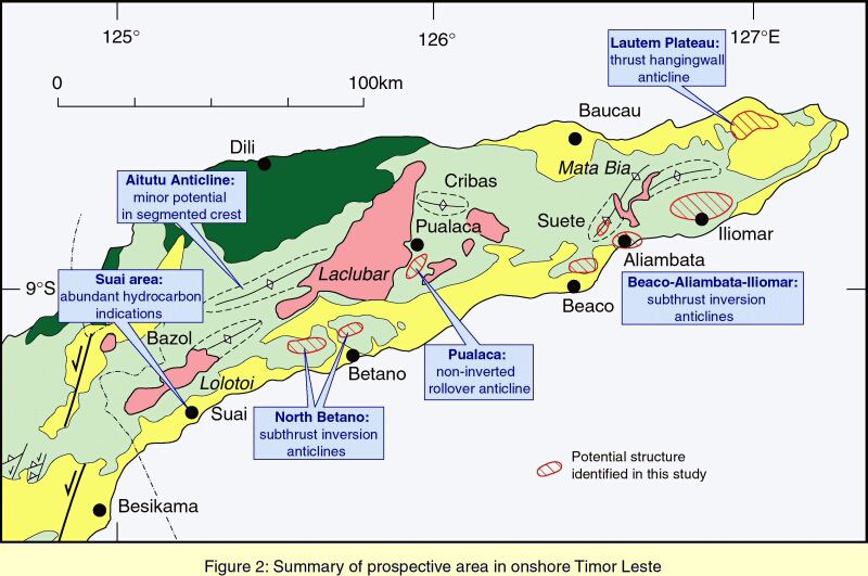
Comparably sized inversion anticlines are exposed by deep erosion in northern and central Timor Leste (e.g. the Cribas, Aitutu and Bazol anticlines). In southern East Timor prospective inversion anticlines are interpreted in the subsurface. The best defined example is situated to the northwest of Betano. The Northwest Betano inversion anticline has an interpreted elliptical closure some 12km long and 6km wide, with a vertical closure of several hundred metres. Small oil seeps surrounding the Northwest Betano anticline to the south, northwest and southeast are interpreted to be sourced from the spill points of this large structure. A second, less-well defined inversion anticline may lie to the northeast of Betano. A number of additional inversion anticlines are provisionally identified, e.g. in the Aliambata, Iliomar, Suai and Suete areas (Figure 2), but a lack of sufficient geological data prohibits complete delineation of these features. Other potentially hydrocarbon-trapping structures in Timor Leste include a rollover anticline at Pualaca, and large domal culminations with associated oil seeps in easternmost Timor Leste, beneath the Lautem Plateau (Charlton, 2002b). Additional structural and stratigraphic traps (sedimentary pinchout, rollover anticlines) are potentially also present in the geologically young basins along the south coast of Timor Leste.
The island of Seram has been described as a geological mirror image of Timor across the Banda Sea (Audley-Charles et al., 1979). The fact that Seram is also the location of longstanding oil production and recent exploration success is very encouraging for hydrocarbon exploration in Timor.
The recently developed Oseil oil field in Seram is a particularly positive analogue for Timor exploration. Prior to the discovery of Oseil, all the oil production in Seram was from small, shallow fields in the Bula area, which are hosted in very shallow reservoirs, typically at depths of only a few hundred metres. In effect the Bula fields can be considered as oil seeps from deeper geological levels that have been arrested near to the ground surface. This type of exploration play has already been extensively tested without noticeable success in the Suai area of Timor Leste, and does not therefore provide much optimism for further exploration in Timor. In contrast, however, the Oseil field, discovered by Kufpec and partners in 1993, is a moderately large oil field (>40 million barrels of oil reserves) located at a depth of about 1600m (Nilandaroe et al., 2002). The Oseil field is located within an inversion anticline of the type here considered highly prospective in Timor Leste. The full potential of inversion anticlines in Timor Leste is difficult to assess without a more detailed knowledge of the geology within the inversion anticlines, and this can only be more confidently assessed with newly acquired seismic reflection data, and ultimately by drilling. However, as a comparison of scale, the Northwest Betano anticline probably contains a volume of rock about twice the size of the Oseil inversion anticline. The Northwest Betano structure is therefore capable of containing a significantly sized, potentially even giant, hydrocarbon accumulation.
Timor Leste is fortunate to have large proven hydrocarbon reserves in the offshore Joint Petroleum Development Area. However, there is a very real possibility that three-way boundary disputes between Timor Leste, Australia and Indonesia will tie up these resources in legal disputes for many years to come. There is, in contrast, no dispute as to sovereignty over any hydrocarbon resources discovered onshore, and it would seem sensible to pursue onshore hydrocarbon exploration in Timor Leste as a primary national priority. In the short term early licensing of onshore exploration would generate revenue through the licensing process (perhaps small in absolute terms, but significant for Timor Leste), and would also benefit local employment through the exploration programmes. In the longer term onshore hydrocarbon resources could prove as economically important as the offshore resources, particularly as secondary sources of revenue such as the trans-shipment and/or refining of any oil and gas produced would accrue directly to Timor Leste, rather than benefiting Timor Leste’s neighbours.
Audley-Charles, M.G. 1968. The geology of Portuguese Timor. Memoir of the Geological Society of London 4.
Audley-Charles, M.G., Carter, D.J., Barber, A.J., Norvick, M.S. & Tjokrosapoetro, S. 1979. Reinterpretation of the geology of Seram: implications for the Banda Arcs and northern Australia. Journal of the Geological Society of London 136, 547-568.
Bemmelen, R.W. van. 1949. The Geology of Indonesia. Government Printing Office, The Hague.
Boutakoff, N. 1968. Oil prospects of Timor and the outer Banda Arc, S.E. Asia. Australasian Oil and Gas Review 14, 44-55.
Charlton, T.R. 2002a. The petroleum potential of West Timor. Proceedings of the Indonesian Petroleum Association Annual Convention 30(1), 301-317.
Charlton, T.R. 2002b. The petroleum potential of East Timor. APPEA Journal 32, 20-38.
Charlton, T.R. 2002c. The Petroleum Potential of East Timor. Oil industry consultancy report. A summary can be viewed at www.manson.demon.co.uk .
Cross, I, 2000. The search for oil and gas on East Timor: Petroleum Exploration Society of Great Britain Newsletter, February 2000, 62-66.
Crostella, A.A. & Powell, D.E. 1976. Geology and hydrocarbon prospects of the Timor area. Proceedings of the Indonesian Petroleum Association Annual Convention 4, 149-171.
Gageonnet, R. & Lemoine, M. 1958. Contribution a la connaissance de la geologie de la province portugaise de Timor. Estudos Ensoaios e Documentos, Junta da Investigacao Ultramar 48, 1-138.
Gageonnet, R., Lemoine, M. & Trumpy, D. 1959. Problemes petroliers dans la province portugaise de Timor. Revue Institut France de Petrole 14, 446-473.
Hardjono, Wahyudi, S. & Gunawan, R. 1996. New concept for hydrocarbon exploration in the "Zone C" Timor Gap and surrounding, Timor Sea, Indonesia. Proceedings of the Annual Convention of the Indonesian Association of Geologists 25, 346-383.
La’o Hamutuk, 2002. Chronology of oil and gas developments in the Timor Sea. La’o Hamutuk 3(8).
Nilandaroe, N., Mogg, W. & Barraclough, R. 2002. Characteristics of the fractured carbonate reservoir of the Oseil field, Seram island, Indonesia. Proceedings of the Indonesian Petroleum Association Annual Convention 28(1), 439-456.
Peters, K.E., Fraser, T.H., Amris, W., Rustanto, B. & Hermanto, E. 1999. Geochemistry of crude oils from eastern Indonesia. Bulletin of the American Association of Petroleum Geologists 83, 1927-1942.
Reed, T.A., de Smet, M.E.M., Harahap, B.H. & Sjapawi, A. 1996. Structural and depositional history of East Timor. Proceedings of the Indonesian Petroleum Association Annual Convention 25, 297-312.
Sani, K., Jacobson, M.L. & Sigit, R. 1995. The thin-skinned thrust structures of Timor. Proceedings of the Indonesian Petroleum Association Annual Convention 24, 277-293.
Sawyer, R.K., Kartono Sani & Brown, S. 1993. Stratigraphy and sedimentology of West Timor, Indonesia. Proceedings of the Indonesian Petroleum Association Annual Convention 22, 1-20.
Sitompul, N., Wijanto, S. & Purnomo, J. 1993. Tectonic evolution of frontier Indonesian Timor Sea. Proceedings of the Annual Convention of the Indonesian Association of Geologists 22, 92-102.
Wittouck, S.F., 1937. Exploration of Portuguese Timor: Report of Allied Mining Corporation to Asia Investment Co., Ltd. Kolff & Co., Batavia & Amsterdam.
![]()
Tim Charlton received his Ph.D. from London University in 1987 for a geological study of southern West Timor and the Timor Trough to the south. He subsequently undertook postdoctoral geological studies in eastern Indonesia, particularly in the Tanimbar and Kei island groups. Since 1990 he has been an independent consultant and researcher specialising in the eastern Indonesian region, and – in the last three years – Timor Leste. He is an Honorary Research Fellow at University College London.
Contact: Tim Charlton, 1 Saint Omer Ridge, Guildford, Surrey GU1 2DD, U.K. charlton@manson.demon.co.uk
The Timor-Leste Institute for Development Monitoring and Analysis (La’o Hamutuk) |
