Printer-friendly PDF version. (28 pages)
Cover Letter from Petro Timor
April 22, 2002
At the request of several elected members of East Timor's Constitutional Assembly who attended Petrotimor's March 23-24 oil and gas seminar held in Dili, Petrotimor is pleased to provide the attached legal opinion in support of what was discussed regarding East Timor's legitimate maritime boundaries. The opinion has been prepared by three eminent specialists in the field of public international law, Professor Vaughan Lowe of Oxford University, Mr. Christopher Carleton of the UK Marine Hydrographic Office and Mr. Christopher Ward of the Australian Bar.
By providing this opinion, Petrotimor seeks to help East Timor to secure international recognition of East Timor's legitimate seabed boundaries, which based upon international law including the 1982 United Nations Convention on the Law of the Sea (UNCLOS), would justify boundaries including the proven reserves of Greater Sunrise, Laminaria/Corralina and Bayu-Undan. This would add about 2 billion barrels to the current reserves and triple the proven reserves under East Timor sovereignty.
In exchange for relinquishing such of its rights under its December 1974 concession agreement as required to ensure the uninterrupted continuation of production sharing contracts (PSCs) heretofore negotiated with the Joint Authority, and for funding these and future legal expenses on behalf of East Timor regarding its legal maritime boundaries, Petrotimor would expect to participate in the additional government revenues presently attributed to Australia which result from the extension of East Timor's seabed boundaries. This would ensure the ongoing recognition of the existing oil company consortium agreements so as not to delay East Timorese tax and production revenues.
The 20% state ownership participation in PetroTimor would continue to be held by the government of East Timor. In addition, Petrotimor would invest a further 20% of its profits in East Timor businesses.
Petrotimor wishes to support the development of an East Timor port facility for onshore processing of LNG. This long-term project could result in major infrastructure, training, employment, and economic benefits to East Timor. In this context, construction of a deep-sea pipeline is feasible. Appropriate government sponsored investment incentives could encourage the existing oil company consortia to favor the East Timor location.
Petrotimor also supports the early negotiation with Australia for transfer to East Timor of current producing royalties (estimated at US$2 billion over the project's 15 year life) arising from Laminaria/Corralina crude oil production, to which East Timor would be entitled under international law including UNCLOS.
Respectfully,
Charlie Haas President Oceanic Exploration Company
Karsten Blue Director Petrotimor
Pedro Carrascalão East Timor Representative Petrotimor
OPINION
by
Vaughan Lowe, Chichele Professor of Public International Law, Oxford University;
Barrister, Essex Court Chambers, London
Christopher Carleton, Head, Law of the Sea Division, UK Hydrographic Office
Christopher Ward, Barrister-at-Law, Wentworth Chambers, Australia
11 April 2002
1. We have been asked to advise upon the geographical extent of the legal entitlement of East Timor to control seabed resources in the Timor Sea, in the light of the terms of existing agreements concerning seabed resources in that area and of the proposed treaty between Australia and East Timor that was attached to the Memorandum of Understanding between representatives of Australia and of the East Timor Transitional Administration, dated 5 July 2001.
2. The limit of the sea-bed jurisdiction of East Timor has been a contentious and disputed issue since the late 1960s. It has involved at least four states, Indonesia, Australia, Portugal and now East Timor; and it remains unresolved. It is important that East Timor be fully advised prior to entering into any agreement that defines the limits of its rights over the seabed, even a 'temporary' or provisional agreement, because any such agreement may materially affect East Timor's long-term entitlement to the resources of the seas and seabed off its coasts.
3. Although attention appears to have focused hitherto upon East Timor's entitlement to a continental shelf, its entitlement to an Exclusive Economic Zone ('EEZ') is a crucial element in the determination of the limits of its seabed rights. We will deal with the continental shelf and the EEZ in turn, explaining some of the historical background to these legal concepts because of the light that it casts upon the changes in the legal context that have occurred since the first maritime boundary agreements in the Timor Sea were concluded in the early 1970s.
4. The legal zone of the continental shelf is an area of maritime jurisdiction that originated in customary international law, with the Truman proclamation of 28 September 1945. That proclamation declared that the United States had jurisdiction and control over "the natural resources of the subsoil and seabed of the continental shelf beneath the high seas but contiguous to the United States". No geographical limit to the claim was set out in the Proclamation, but it was clearly limited to the 'continental shelf', which is in geological and geomorphological terms the undersea extension of the landmass, as distinct from the deep ocean sea-bed which is not an extension of the landmass. Accordingly, the essential criterion was one of physical geography: States' rights extended over the physical continental shelf adjacent to their coasts.
5. A note issued at the same time as the Truman Proclamation observed that the physical continental shelf was usually defined as the sea-bed adjacent to the coast out to a depth of 100 fathoms (600 feet). International law took a slightly different view. Article 1 of the 1958 Continental Shelf Convention stipulated that coastal State rights extended out over the seabed "to a depth of 200 metres or, beyond that limit, to where the depth of the superjacent waters admits of the exploitation" of the sea-bed resources, it being understood that this depth criterion was still confined to the area that constituted the seaward extension of the landmass the physical continental shelf (or, more accurately, the physical continental margin).
6. The 1958 Convention was said by the International Court of Justice ('ICJ') in the 1969 North Sea Continental Shelf (ICJ Reports 1969, 3) cases to have crystallised the customary doctrine by which the outer limits of the continental shelf were defined by reference to the physical extension of the landmass below the adjacent sea and the depth to which it was possible to exploit the resources of the continental shelf.
7. In cases where two or more States lie opposite or adjacent to one another on the same continental shelf, the 1958 Continental Shelf Convention stipulated that the boundaries of the shelves appertaining to each of them were to be determined by agreement, failing which (and in the absence of special circumstances a point to which we return below in paragraphs 34 and 35) the boundary would be "the median line, every point of which is equidistant from the nearest points of the baseline from which the breadth of the territorial sea of each State is measured." (Article 6(1)). The baseline is ordinarily the low-water mark around the coast, although the sinuosities of the low-water mark are often simplified by the use of straight baselines connecting appropriate points on the low-water mark along the coast.
8. The 1958 Convention is significant because Portugal and Australia became Parties to that Convention in 1963 (although Indonesia never became a Party to it). Therefore, the provisions of the Convention represented the law that applied between Portugal and Australia at least until 1975, when East Timor was unlawfully occupied by Indonesia.
9. Portugal and Australia did not reach any agreement as to the boundary of the continental shelf between Australia and the then Portuguese province of Timor. In the early 1970s Australia argued that the Timor Trough represented the northern boundary of Australia's physical continental shelf, and therefore of its legal entitlement. Australia regarded the shelf north of the Timor Trough as a quite separate continental shelf, appertaining to Indonesia and Portugal / East Timor. By contrast, Portugal appears to have taken the position that the Timor Trough was not such a geologically significant feature in this context as to divide the seabed in the Timor Sea into two separate continental shelves, north and south; that there was accordingly a single physical shelf to be divided between Portugal and Australia; and that the legal continental shelf of East Timor therefore extended to the median line between Australia and East Timor, which is much further south than the Timor Trough.
10. Australia's position in the 1970's was arguably inconsistent with the geology of the Timor Trough, which is similar to other sea-bed depressions that have not been treated by international law as constituting a break in a continental shelf. Examples of other deep depressions, of a similar or greater depth than the Timor Trough, that have been treated as not breaking a single continental shelf include:
11. Indeed, as early as 1977, in the Anglo-French case, the arbitral tribunal had commented that:
"to attach critical significance to a physical feature like the Hurd Deep . . . in delimiting the continental shelf boundary . . . would run counter to the whole tendency of State practice on the continental shelf in recent years." (18 ILM 397 at 428 (1979)).
Thus, even applying the concept of natural prolongation under the 1958 Continental Shelf Convention, Australia's arguments were open to serious doubt.
12. Additionally, Australia's position in the 1970s was not necessarily consistent with the jurisprudence of the International Court of Justice ("ICJ") in the North Sea Continental Shelf cases (Germany / Denmark, Germany / Netherlands, ICJ Reports 1969, 3). In its decision in those cases the ICJ determined that although the concept of natural prolongation of the physical continental shelf was fundamental, the result of any delimitation must take into account considerations of equity and fairness between opposing states: see paragraphs 20 and 89ff of the judgment. The manifest inequity and unfairness of Australia, with its entitlement to vast maritime zones around its coasts, forcing the continental shelf entitlement of Portugal / East Timor into a narrow strip north of the Timor Trough, explains the failure of Portugal to agree to the position upon which Australia insisted at that time.
13. Indonesia did, however, conclude seabed boundary agreements with Australia, in 1971 and 1972. The 1972 agreement established boundaries in the Timor Sea. Those boundaries correspond closely with the position advanced by Australia, and reflect the extremely hard bargain driven by Australia at that time. The 1972 agreement established boundaries between the Australian and Indonesian continental shelves in the areas to the west and to the east of the seabed off Timor, leaving a gap (the 'Timor Gap') in between the terminal points of the two segments of the agreed boundaries, in which there was no agreed delimitation. It provided, moreover, that the Australia-Indonesia boundaries adjacent to the Timor Gap might be adjusted by agreement in the event of an agreement between Australia and Portugal on delimitation in the Timor Gap. As we noted in paragraph 12 above, Australia and Portugal did not reach agreement on the delimitation of the seabed in the Timor Gap.
14. The position changed after the Indonesian invasion of East Timor. The Indonesian invasion was patently unlawful, and Indonesia had no legal right to dispose of the seabed off East Timor. Australia was nonetheless willing to conclude a treaty with Indonesia that purported to divide up the continental shelf in the Timor Sea. It is not necessary for the purposes of this Opinion to consider the question of the legality or illegality of the 1989 Timor Gap Treaty itself.
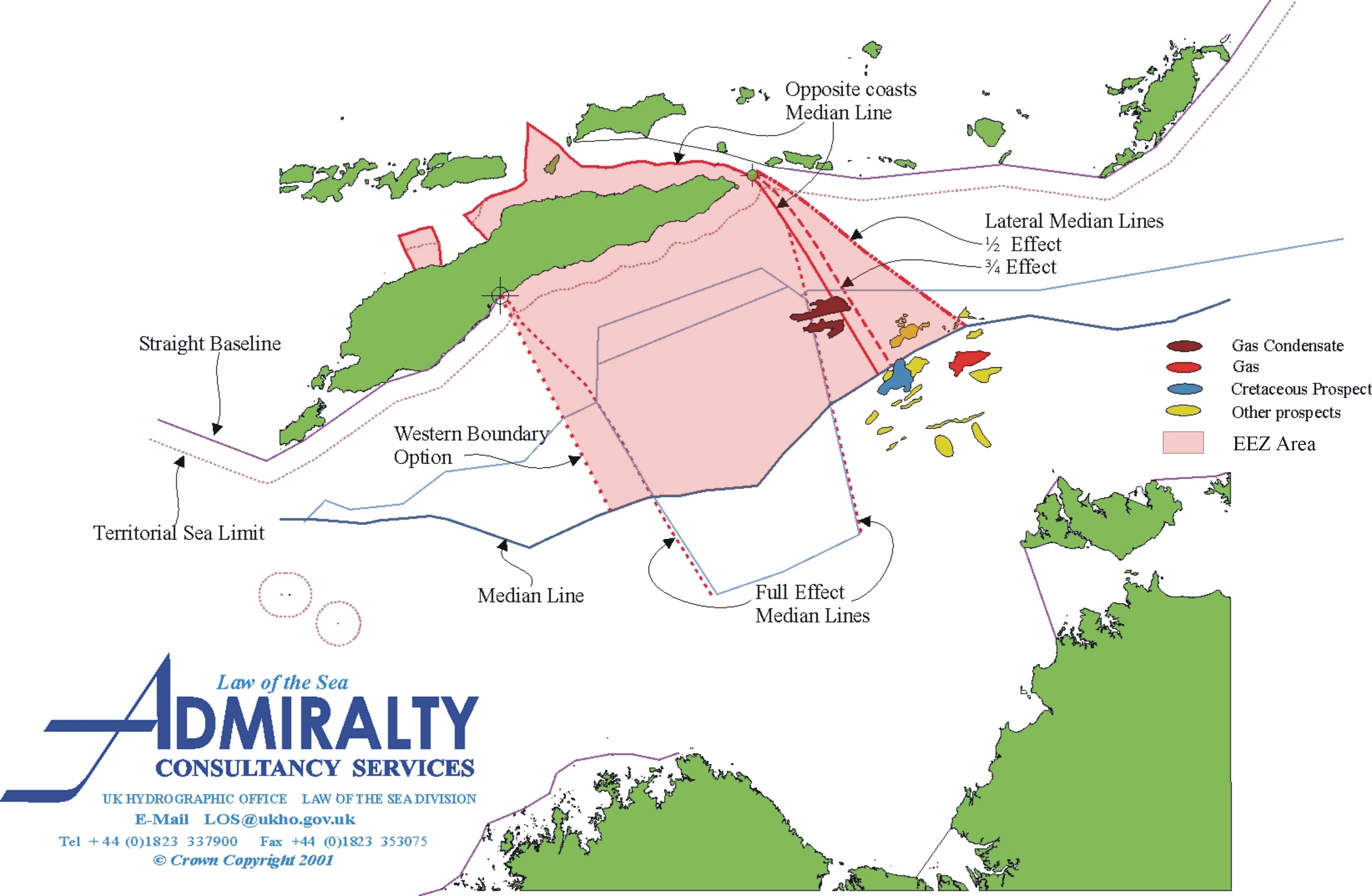
15. The horizontal (west-to-east) lines defining the zones in the 1989 Timor Gap Treaty reflected the earlier arguments of Australia based upon the natural prolongation of the Australian continental shelf northwards, up to the Timor Trough. The Treaty established three zones of jurisdiction, which together made up the 'Zone of Co-operation', in the area of the continental shelf between Australia and East Timor. The three zones were bounded on the west and east by what were loosely described as lateral median lines (a matter to which we return below, at paragraph 37ff.). According to one Australian Government lawyer, the three zones were delimited by the following west-east lines (in order, starting with the most northerly):
a simplified line along the 1500 metre isobath, representing the deepest part of the Timor Trough (which lies close to the line that would join the terminal points of the Australia-Indonesia agreements) [marked 'B' on the diagram];
the median line between Australia and East Timor [marked 'C' on the diagram]; and
a line 200 miles from East Timor, representing the maximum possible extent of a future Exclusive Economic Zone of East Timor [marked 'D' on the diagram].
The diagram indicating those lines, and identifying the three zones as zones A, B and C (as in the 1989 Timor Gap treaty), is set out below, as the Appendix.
16. The lateral or side lines defining of the 1989 Zone of Co-operation were drawn by taking so-called "simplified equidistance lines" between East Timor and Indonesia. They were based substantially on the location of the termini of the 1971 and 1972 seabed limits agreed between Australia and Indonesia. Each of the lateral lines has two segments, resulting in the 'coffin' shape of the Zone of Cooperation.
17. On the western side, the northerly segment was drawn by taking a perpendicular line from the end of the Timor Trough to the point known as A17, which was the point at which the easterly segment of the boundary drawn in the 1972 agreement ended. This had the effect of bringing within the Zone of Co-operation the maximum extent of Australia's claim to a continental shelf, extending right up to the Timor Trough. The second, southerly, part of the western boundary of the Zone of Co-operation seems to have been determined by taking a line from point A17 and extending it to the southern boundary of the Zone of Co-operation, in the direction of a line drawn from Cabo Tafara in East Timor to Point A17.
18. On the eastern side the longest, southerly, segment of the lateral line was drawn by taking a line perpendicular to the small Indonesian island of Leti and extending it to the southern-most boundary of the Zone of Co-operation.
19. For the reasons given below, none of the lines, horizontal or lateral, laid down in the 1989 Timor Gap Treaty determine the modern limits of the sea-bed to which East Timor is entitled.
20. Since 1975 the legal position has changed fundamentally from that which existed in the early 1970s. In particular, the entitlement under customary international law of all States to claim an Exclusive Economic Zone has been recognized, and has been codified in the 1982 UN Convention on the Law of the Sea ('UNCLOS').
21. Article 57 of UNCLOS entitles States to declare the existence of an EEZ up to a distance of 200 nautical miles from the coast. The declaration of an EEZ grants to the coastal state the exclusive right to exploit both the resources of the water column (e.g., fish), and the resources of the sea-bed and subsoil (e.g., oil and gas), in that zone.
22. Within its EEZ a State has "sovereign rights for the purpose of exploring and exploiting, conserving and managing the natural resources, whether living or nonliving, of the waters superjacent to the sea-bed and of the sea-bed and its subsoil" (UNCLOS, Article 56(1)(a)). In other words, it has exclusive rights to exploit both the resources of the water column and the resources of the sea-bed.
23. The EEZ therefore offers a legal basis for exclusive coastal State rights over seabed resources within 200 miles of the coast that is additional or alternative to the rights arising from the legal entitlement to a continental shelf. Rights to sea-bed resources more than 200 miles from the coast, in contrast, can be based only on the continental shelf regime, because EEZ rights cannot extend more than 200 miles. The conference that drafted the UNCLOS between 1973 and 1982 was well aware of the duplication of the basis of rights over sea-bed resources,and deliberately decided to include both sets of rights in the Convention.
24. The EEZ is a maritime zone that every coastal State may claim. It is recognised both in customary international law and also under UNCLOS. That position was confirmed by the decision of the ICJ in the Libya / Malta Continental Shelf case (ICJ Reports 1985, 13 at 33). In other words, a State need not rely on the provisions of UNCLOS and need not be a party to UNCLOS before declaring an EEZ.
25. The result is that East Timor is absolutely entitled to declare an EEZ, whether or not it has ratified the 1982 United Nations Convention on the Law of the Sea. We note that Section 4 of the final draft of the Constitution of East Timor may be read as asserting the existence of an East Timor EEZ. Section 4 provides that "(1) The territory of the Democratic Republic of East Timor comprises the land surface, the maritime zone and the air space demarcated by the national boundaries that historically comprise the eastern part of Timor Island, the enclave of Oecussi, the island of Ataúro and the islet of Jaco (emphasis added)." It goes on to provide that "(2) The extent and limits of territorial waters and the exclusive economic zone, and the rights of East Timor to the adjacent seabed and continental shelf shall be laid down in the law (emphasis added)." The implication appears to be that the existence of the EEZ is asserted in the Constitution, although its extent and limits remain to be settled. Since there is not a single instance of an EEZ claim to any distance other than 200 miles, it is in practice only the limits of East Timor's EEZ that could remain to be settled.
26. A State that has declared an EEZ is entitled as of right to exercise exclusive sovereign rights in respect of the exploration and exploitation of the resources of the sea-bed within that zone. Those rights extend out to 200 miles from the coast. The limit of the EEZ is measured purely in terms of distance. Neither 'natural prolongation', nor the physical characteristics of the sea-bed, nor the depth of the superjacent waters, has any role to play. In this respect the EEZ is radically different from the old '1958' continental shelf regime.
27. This is reflected in the UNCLOS provisions concerning the regime of the continental shelf (which, as we noted in paragraph 23, overlaps with the EEZ seabed rights). Thus, UNCLOS Article 76 defines the continental shelf as extending either (a) out to the edge of the physical continental margin, or (b) out to 200 miles from the coast where the continental margin does not extend that far. The first element, (a), reflects the old '1958 Convention' definition of the continental shelf; and the second is a consequence of the entitlement to sea-bed rights under the 200 mile EEZ regime. The definition of the continental shelf in UNCLOS Article 76 reflects the continental shelf entitlement of States under current customary international law.
28. Accordingly, even if East Timor were not to claim an EEZ, it would be entitled to a continental shelf of at least 200 miles. Moreover, unlike an EEZ, which must be claimed, continental shelf rights exist automatically. They do not depend upon any claim or proclamation, but attach automatically to every coastal State: see UNCLOS Article 77(3).
29. It follows that the concept of natural prolongation of a continental shelf has no relevance where two States are less than 400 nautical miles apart and where each has declared an EEZ. That is the situation in relation to East Timor. Australia has declared an EEZ; and as we noted above the draft Constitution of East Timor appears to assert the existence of an East Timor EEZ, and East Timor will in any event benefit from the automatic appurtenance of a legal continental shelf to its land territory.
30. The irrelevance of 'natural prolongation' and the physical characteristics of the seabed in these circumstances was recognized in the decision of the ICJ in the case of Libya / Malta Continental Shelf case (ICJ Reports 1985, 13 at 35). The ICJ accepted that delimitation by reference to distance had replaced principles of natural prolongation in areas of continental shelf within 200 nautical miles of the coast of one or other State. The Court said that, within the 200 nautical mile zones, "there is no reason to ascribe any role to geological or geophysical factors" (at p. 35).
31. Therefore, Australia's historical arguments in relation to the natural prolongation of its continental shelf, whether or not those arguments were valid in the early 1970s, are now quite clearly irrelevant to the delimitation with East Timor. Instead, Australia and East Timor must determine the boundary of their overlapping entitlements to a 200 mile EEZ, and to a 200 mile continental shelf, on quite different principles.
32. The current position in international law is that where two States oppose each other such that their EEZs would overlap if each claimed a full 200 nautical miles, both Article 74 of UNCLOS and customary international law require those States either to negotiate an agreed boundary between their EEZs on the basis of international law, or alternatively to settle the dispute by some peaceful means of their own choosing, in either case "in order to reach an equitable solution". Article 83 of UNCLOS, and customary international law lay down an essentially identical obligation in relation to overlapping continental shelf claims.
33. The central requirement of modern international law is the requirement that EEZ and continental shelf boundaries be equitable. A maritime delimitation must take into account all of the relevant circumstances, in order to achieve an equitable result: see the Gulf of Maine Case (ICJ Reports 1984, 246 at 300, 312-313); Tunisia / Libya Continental Shelf (ICJ Reports 1982, 18 at 59-61); Jan Mayen (ICJ Reports 1993, 37 at 58-59, 63). Nonetheless, because the 200 mile distance criterion has replaced natural prolongation as the basis of sea bed rights within that zone, delimitation on the basis of simple geography has the predominant role in achieving an equitable solution.
34. The natural starting point, both in theory and practice, in the search for an equitable solution is the median line, which divides the area equally between the contesting States. That was recognized in the Libya / Malta Continental Shelf case, where the ICJ declared that:
"the equitable nature of the equidistance method is particularly pronounced in cases where the delimitation has to be effected between States with opposite coasts" (ICJ Reports 1985, 13, at 47).
Thus, it is clear that where delimitation of a sea-bed boundary between opposite States is to take place within overlapping EEZ or continental shelves, the median line would normally form the line of division, in the absence of special circumstances to the contrary.
35. There do not appear to be any special circumstances between Australia and East Timor that would compel departure from a median line. Therefore, a line close to the median line between Australia and East Timor would very probably be the appropriate boundary determined according to international law. East Timor would have exclusive rights to the resources north of that line.
36. The result is that there is no reason why East Timor should now concede that there is any Australian interest in resources that lie north of the median line between East Timor and Australia. The 5 July 2001 Memorandum of Understanding proposes to perpetuate a Joint Petroleum Development Area (in what is Zone A of the Zone of Co-operation established in the 1989 Timor Gap Treaty) between Australia and East Timor in an area north of the median line. It therefore appears to be based upon the 1970s Australian claim to continental shelf rights over the "natural prolongation" of the Australian shelf up to the Timor Trough. That claim is not consistent with current international law, and there is no obvious reason why any current arrangement should be based upon it.
37. The eastern and western lateral lines of the 1989 Australia-Indonesia Timor Gap treaty (which are reflected in the 5 July 2001 Memorandum of Understanding) are equally indefensible in modern international law.
38. The western lateral line proceeds from the wrong starting point in the land mass of Timor and passes through point A17 (drawn by Australia and Indonesia in 1971/72). East Timor need not accept the accuracy of Point A17 as the lateral limit of its EEZ. Indeed, Australia and Indonesia expressly provided in Article 3 of their 1972 sea-bed boundary treaty that Point A17 might have to be moved in the light of any delimitation of the sea-bed in the Timor Gap. In fact, if the lateral line proceeded from the correct point (the thalweg of the Moti Masin) the line would move somewhat to the west of the existing line.
39. The eastern line was drawn from a point between East Timor and the small Indonesian island of Leti, and connects with Point A16 in the 1972 Australia-Indonesia treaty. Again, East Timor should not assume the accuracy of point A16, which was also covered by the provision for adjustment in Article 3 of the 1972 treaty.
40. More significant than that is the fact that the eastern lateral line was drawn giving full weight to the island of Leti. That is to say, the line was drawn so that all points on it were equidistant from East Timor and from the nearest points on Leti or other Indonesian islands. Modern international law, however, does not permit small islands to have a disproportionate and inequitable effect upon maritime boundaries. The law requires that small islands that would disproportionately affect a maritime delimitation be given only a proportional effect - perhaps one half or three-quarters effect, depending on the size of the island and its relationship to the coastline. For example, one hypothetical equidistance line might be drawn giving full effect to Leti (resulting in the line in fact used in the 1989 Treaty), and another hypothetical equidistance line drawn disregarding Leti. The actual boundary might then be drawn half way between those two hypothetical lines, in order to give half effect to Leti, or three-quarters of the way towards the westerly hypothetical line so as to give Leti three-quarters effect.
41. This approach is now very firmly established in the practice of international courts and tribunals. ICJ and arbitration cases routinely discount the effect given to small islands that would inequitably or disproportionately affect the delimitation. This was done, for example, by the arbitral tribunal in the Western Approaches case (1977) between France and the United Kingdom, where the United Kingdom¹s Scilly Isles were given half weight; and by the ICJ in the Tunisia/Libya case (1982), in which the Tunisian Kerkennah islands were given half weight. In the Dubai/Sharjah case (1981), Sharjah's island of Abu Musa was in effect ignored, by giving it no continental shelf beyond its territorial sea - a solution that had also been applied by the tribunal in the Western Approaches arbitration to correct the disproportionate effect of the United Kingdom¹s Channel Islands on the delimitation. More recently, the approach was applied by the ICJ in the Qatar/Bahrain case (2001). The approach has also been applied in State practice, in maritime boundaries established by agreement between the States concerned.
42. If half or three-quarters effect were given to the island of Leti, the eastern lateral line dividing East Timor's EEZ from the EEZs of Australia and Indonesia would move significantly to the east. That would have the practical effect of placing most or all of the Greater Sunrise field within East Timorese jurisdiction, and greatly increasing the resources under East Timor's control.
43. The 5 July 2001 Memorandum of Understanding has attached to it a proposed treaty text, named the 'Timor Sea Arrangement', that is said to be "suitable for adoption" by an independent East Timor. That proposed treaty text has not yet been adopted. Nor is there any legal obligation whatever upon East Timor to adopt it, when East Timor becomes independent. Indeed, the 5 July 2001 Memorandum does not suggest that there is, or that the Parties intended that there should be, any such obligation upon East Timor.
44. Under the proposed treaty, East Timor and Australia would share revenues from what is currently zone A of the Zone of Co-operation established in the 1989 Australia-Indonesia Timor Gap Treaty, in a 90%/10% proportion in favour of East Timor. (That area, the existing zone A, is termed the Joint Petroleum Development Area ('JPDA') in the proposed treaty.) For the reasons given above, there is no compelling reason in international law for East Timor to surrender 10% of the revenue or resources from that area. It may claim full rights, admitting no Australian interest, in the area north of the median line.
45. The proposed treaty is similarly at odds with current international law when the proposed lateral boundaries are considered. The proposed treaty would adopt the lateral boundaries of the Zone of Co-operation established by the 1989 Australia - Indonesia Timor Gap Treaty. Resources to the west of that area and south of the 1972 sea-bed boundary established by Australia and Indonesia are to be exploited entirely by Australia. Resources to the east, in the Greater Sunrise Field, are to be shared 80% to Australia and 20% to the JPDA, on the basis that 20% of the Greater Sunrise Field lies within the JPDA. As was explained above, the lateral lines do not represent the full extent of East Timor's sea-bed entitlement under current international law. They perpetuate the boundaries set up in the 1989 Australia-Indonesia treaty, and would result in East Timor having significantly reduced rights over its legitimate sea-bed.
46. The proposed treaty does purport to permit renegotiation of sea bed points within the JPDA. Article 2 provides that "Nothing contained in this Arrangement and no acts taking place while this Arrangement is in force shall be interpreted as prejudicing or affecting East Timor's or Australia¹s position on or rights relating to a sea-bed delimitation or their respective sea-bed entitlements." There are, however, two difficulties with this provision, which severely reduce its efficacy.
47. The first is that, whatever the theoretical status of that provision, in practice it would undoubtedly compromise East Timor¹s claims to areas outside the proposed JPDA. We noted above that international law requires that delimitations achieve an 'equitable result'. In the absence of a permanent sea-bed delimitation, the duration specified in Article 22 of the proposed treaty is thirty years, with the option of renewal thereafter. During the life of the treaty Australia would have exclusive rights over the seabed outside the JPDA. If that is considered an acceptable arrangement by Australia and East Timor when they enter into the treaty, it is not probable that any tribunal adjudicating upon the Australia-East Timor boundary would regard the boundary as inequitable if the matter were submitted for delimitation at some time in the future. (That is, for example, much like the handling of a similar issue by the ICJ in comparable circumstances in the Tunisia / Libya Continental Shelf case: ICJ Reports 1982, 3, at 84). It is much more likely that any such tribunal would regard the treaty, and the saving clause in its Article 2 quoted above, as limiting the area in need of delimitation to the area confined within the boundaries of the JPDA.
48. On that basis, East Timor would in practice lose the right to contest the validity of the lateral boundaries, and the right to claim any sea-bed south of the Australia- East Timor median line that is the southerly boundary of the JPDA. East Timor might still argue that it is entitled to the entire JPDA, down to the median line, and that Australia is entitled to none of it. (That is the area to which we consider that East Timor has a good legal claim at present.) It would, however, be extremely unusual for a tribunal to give 100% of a disputed maritime area to one of the disputing parties.
49. To put the matter at its lowest, it would be very imprudent for East Timor to accept the proposed treaty if it wished to preserve a claim to a wider entitlement, particularly to any areas lying beyond the JPDA.
50. The second difficulty relates specifically to the eastern lateral boundary of the proposed JPDA. Article 9 of the proposed treaty stipulates that cross-boundary petroleum deposits shall be treated as a single entity for management and development purposes, i.e., unitised. Annex E of the proposed treaty provides for the unitisation of the Sunrise and Troubadour deposits, collectively known as 'Greater Sunrise'. It further stipulates that 80% of Greater Sunrise production is to be attributed exclusively to Australia, the remaining 20% being attributed to the JPDA, in which East Timor has in effect a 90% share. That unitisation of resources under the proposed treaty would survive in the event that sea-bed boundaries were the subject of a later delimitation. Although the Parties would be bound to "reconsider" the terms of the unitisation agreement in the event of a permanent delimitation, they would be under no obligation to modify them. There can, therefore, be no assurance that an independent East Timor would be able to obtain a modification of the terms of the unitisation agreement (for example, a reduction of Australia's 80% share of Greater Sunrise) even if the eastern lateral boundary were shifted to put most or all of Greater Sunrise within East Timor's maritime zone.
51. On 21 March 2002 Australia made a declaration pursuant to Article 287 of UNCLOS to the effect that it chose the International Tribunal for the Law of the Sea ("ITLOS") and the ICJ as the bodies to settle disputes arising under the UNCLOS and involving Australia. However that declaration was made subject to an express reservation in respect of sea boundary delimitations, in respect of which Australia declined to accept the jurisdiction of any of the tribunals to which disputes might be submitted under Part XV, Section 2 of UNCLOS. Such reservations are permitted by UNCLOS Article 298(1)(a).
52. On 25 March 2002, Australia further announced that it had modified the terms of its acceptance of the jurisdiction of the ICJ. In 1975, Australia had made a declaration under Article 36(2) of the Statute of the ICJ to the effect that it accepted the jurisdiction of the ICJ in relation to any States accepting the same obligation. The 2002 modification purports to exclude from that acceptance of ICJ jurisdiction all maritime boundary delimitation disputes, and all disputes concerning the exploitation of an area in dispute or adjacent to an area in dispute.
53. It is clear that the 2002 declarations of Australia aim to avoid third party dispute resolution of its sea-bed boundaries, including its boundaries with East Timor. It is less clear that they have necessarily secured that aim, at least in relation to East Timor.
54. Article 74 of UNCLOS places an obligation on States (including Australia) to settle maritime boundaries in accordance with Part XV of UNCLOS. It is not possible to challenge Australia's limited acceptance of the jurisdiction of ITLOS as a competent tribunal under UNCLOS Part XV. However, the position in respect of the ICJ is less certain.
55. The acceptance by a State of the jurisdiction of the ICJ pursuant to Article 36(2) is a voluntary and consensual act. The result is to create a reciprocal network of bilateral agreements with other States that have also accepted the jurisdiction of the Court under Article 36(2).
56. East Timor could, upon gaining independence, immediately become a Party to the ICJ Statute, and submit the maritime boundary dispute with Australia to the Court. If it did so, two questions would arise.
57. The first question concerns the effect of the revocation of the terms of Australia's 1975 declaration under Article 36(2) accepting ICJ jurisdiction. The 1975 declaration stipulated that it was effective "until such time as notice may be given to withdraw this declaration." It was silent as to the period of notice that would be given for termination or modification, and might accordingly be regarded as a declaration silent as to the manner in which it might be modified.
58. The legal position of such declarations was considered by the ICJ in the case of Nicaragua v United States of America (Jurisdiction), where the Court suggested that Article 36(2) declarations fell into at least three categories:
- declarations that are silent as to the manner in which they may be terminated;
- declarations that are expressly stated to be terminable on a defined period of notice;
- declarations that are expressly stated to be terminable immediately on notice to the Court and the Secretary-General of the United Nations. (ICJ Reports 1984, 392 at 418)
The ICJ indicated that declarations that contained a requirement for an express period of notice could not be terminated other than in accordance with that notice period. However, the Court then went on to suggest that declarations that were silent as to notice periods could be terminated only on provision of "reasonable notice". The Court said:
"the right of immediate termination of declarations of indefinite duration is far from established. It appears from the requirements of good faith that they should be treated, by analogy, according to the law of treaties, which requires a reasonable time for withdrawal from or termination of treaties that contain no provision regarding the duration of their validity" (ICJ Reports 1984, 392 at 420)
59. Those observations would be applicable to Australia's 2002 modification. If East Timor were to become a Party to the ICJ Statute and initiate proceedings in respect of its maritime boundary with Australia, questions would arise as to the need for Australia to give reasonable notice of the modification of its 1975 declaration accepting ICJ jurisdiction, and as to the period of notice that would be "reasonable".
60. The second question that would arise would be complication caused by the fact that although there is clearly a dispute over the East Timor / Australia sea-bed boundary that dates back to the discussions between Australia and Portugal in the 1970s, East Timor had not, at the date of the purported modification by Australia, itself accepted the jurisdiction of the Court, and indeed was unable to do so because it lacked the independent statehood that is necessary in order to become a Party to the Court's Statute (see Article 93 of the UN Charter).
61. This question has not been addressed by the Court, and it is not possible to give a definite opinion on how it would be answered. It may, however, be prudent to consider what steps might be taken to protect so far as is possible the position of East Timor. Given that East Timor is not yet independent, the possibility of an application to the ICJ concerning the maritime boundary dispute being lodged by UNTAET, which application might be confirmed or withdrawn by East Timor when it becomes independent, is plainly worthy of consideration.
For a larger view of this map in a separate window, click here:
